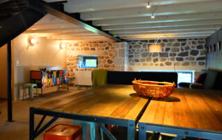
Very comfortable gîte for 10 people, self-catering. This old stone barn, ecologically renovated with respect for materials, will seduce you.
Description
The volume of the dam is 30 m000. It was built between 3 and 1951. Site registered with the Pôle d'Economie du Patrimoine.
When the dam lake is empty, you can observe the traces of the different levels of the lake and the marks of erosion (“mini” canyons) at the bottom.
Partly emptied of its water, the La Palisse dam on the Loire reveals impressive basalt cliffs.
In Ardèche, there is a communication between the lakes and the dam which is used to fill the lake for tourists during the summer and to power turbines which produce electricity.
The monitoring of this dam is very strict, so we monitor the control terminals with binoculars to see if there are slight displacements which would mean cracks.
This dam is on the Loire (which is in its infancy and flows into the Atlantic Ocean) or the water that comes out of the turbines goes into the Ardèche (which it flows into the Rhône and then into the Mediterranean Sea). This is how water from the Atlantic is diverted to the Mediterranean.
On the road which leads to La Palisse you can encounter "the watershed line": on one side of this line the waters of the different rivers end in the Mediterranean Sea (the Ardèche for example) while beyond this line the waters end in the Atlantic Ocean (the Loire for example).
We also offer:

Very comfortable gîte for 10 people, self-catering. This old stone barn, ecologically renovated with respect for materials, will seduce you.
Prices
| Free |
Location